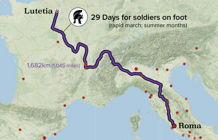
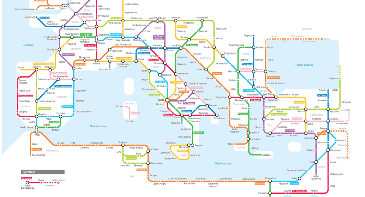
Unless you’re a historian or map buff, interpreting a map of the Roman Empire can be a daunting exercise. Place names are unfamiliar and roads meander across the landscape making it difficult to see the connections between specific cities and towns. Today’s visualization, by Sasha Trubetskoy, has mashed-up two enduring obsessions – transit maps and Ancient Rome – to help us understand the connection between Rome and its sprawling empire. At the height of the Roman Empire, there were approximately 250,000 miles (400,000 km) of roads, stretching from Northern England to Egypt and beyond. This impressive network is what allowed Rome to exercise control and communicate effectively over such a large territory. For a detailed look at travel times and costs, check out Stanford’s amazing ORBIS platform. The screenshot below shows the fastest, cheapest, and shortest routes between the settlement of Lutetia (the predecessor of present-day Paris) and Roma.
There were three main types of roads in Ancient Rome: Viae publicae: Public highways or main roads, typically maintained by the military. These were the main, paved arteries of the empire and often included infrastructure such as drainage, milestones, and way stations. Viae privatae: Private or country roads were financed by wealthy individuals to connect towns and other noteworthy points to the viae publicae. Viae vicinales: These tertiary (often dirt) roads connected villages and areas within districts, eventually linking to the larger network. This network of roads was vital as it allowed for quick troop movement as well as the development of a mail system. As the first major road network in Europe, the Romans quite literally laid the foundation for development across the continent. – Sasha Trubetskoy
The Enduring Influence of Roman Roads
London, Paris, Barcelona, and countless other major cities sprang from Roman settlements along the road network, and even as Europe descended into the Dark Ages (476-800 CE), Roman roads remained as one of few functioning modes of movement and communication. A recent study even points out that proximity to that foundational network of roads even has a strong correlation with economic activity today. Beyond mere curiosity or entertainment, looking back at Roman ingenuity allows us to see the impact their road network had on today’s world. That enduring influence is one of the reasons ancient Rome still fascinates us to this day. For more reading, check out Trubetskoy’s followup, Roman Roads of Britain. on Even while political regimes across these countries have changed over time, they’ve largely followed a few different types of governance. Today, every country can ultimately be classified into just nine broad forms of government systems. This map by Truman Du uses information from Wikipedia to map the government systems that rule the world today.
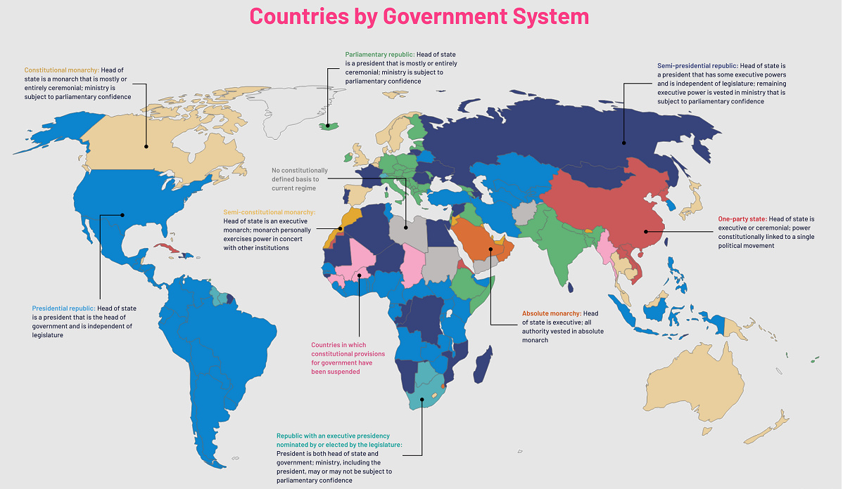
Countries By Type of Government
It’s important to note that this map charts government systems according to each country’s legal framework. Many countries have constitutions stating their de jure or legally recognized system of government, but their de facto or realized form of governance may be quite different. Here is a list of the stated government system of UN member states and observers as of January 2023: Let’s take a closer look at some of these systems.
Monarchies
Brought back into the spotlight after the death of Queen Elizabeth II of England in September 2022, this form of government has a single ruler. They carry titles from king and queen to sultan or emperor, and their government systems can be further divided into three modern types: constitutional, semi-constitutional, and absolute. A constitutional monarchy sees the monarch act as head of state within the parameters of a constitution, giving them little to no real power. For example, King Charles III is the head of 15 Commonwealth nations including Canada and Australia. However, each has their own head of government. On the other hand, a semi-constitutional monarchy lets the monarch or ruling royal family retain substantial political powers, as is the case in Jordan and Morocco. However, their monarchs still rule the country according to a democratic constitution and in concert with other institutions. Finally, an absolute monarchy is most like the monarchies of old, where the ruler has full power over governance, with modern examples including Saudi Arabia and Vatican City.
Republics
Unlike monarchies, the people hold the power in a republic government system, directly electing representatives to form government. Again, there are multiple types of modern republic governments: presidential, semi-presidential, and parliamentary. The presidential republic could be considered a direct progression from monarchies. This system has a strong and independent chief executive with extensive powers when it comes to domestic affairs and foreign policy. An example of this is the United States, where the President is both the head of state and the head of government. In a semi-presidential republic, the president is the head of state and has some executive powers that are independent of the legislature. However, the prime minister (or chancellor or equivalent title) is the head of government, responsible to the legislature along with the cabinet. Russia is a classic example of this type of government. The last type of republic system is parliamentary. In this system, the president is a figurehead, while the head of government holds real power and is validated by and accountable to the parliament. This type of system can be seen in Germany, Italy, and India and is akin to constitutional monarchies. It’s also important to point out that some parliamentary republic systems operate slightly differently. For example in South Africa, the president is both the head of state and government, but is elected directly by the legislature. This leaves them (and their ministries) potentially subject to parliamentary confidence.
One-Party State
Many of the systems above involve multiple political parties vying to rule and govern their respective countries. In a one-party state, also called a single-party state or single-party system, only one political party has the right to form government. All other political parties are either outlawed or only allowed limited participation in elections. In this system, a country’s head of state and head of government can be executive or ceremonial but political power is constitutionally linked to a single political movement. China is the most well-known example of this government system, with the General Secretary of the Communist Party of China ruling as the de facto leader since 1989.
Provisional
The final form of government is a provisional government formed as an interim or transitional government. In this system, an emergency governmental body is created to manage political transitions after the collapse of a government, or when a new state is formed. Often these evolve into fully constitutionalized systems, but sometimes they hold power for longer than expected. Some examples of countries that are considered provisional include Libya, Burkina Faso, and Chad.